SRTM1 (30 m) terrain packs by UN geoscheme — land + 500 km offshore bands, sized for 128 GB cards
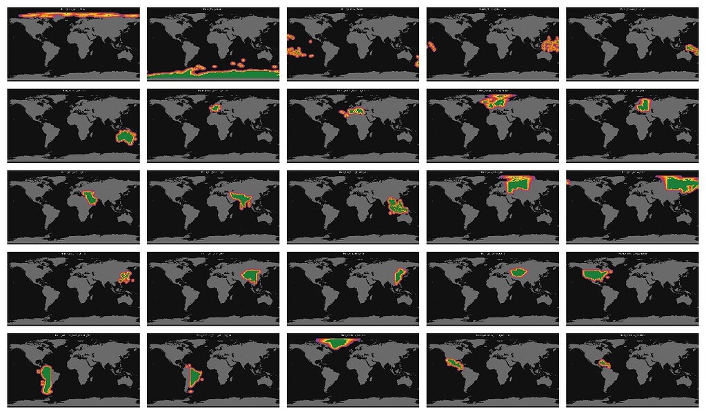
Basically I wanted to get Australia in STRM1 (30m res) for use and wanted to be able to dump it into a >128gb SD, that was not easily available anywhere I could find. So I built a set of offline ArduPilot terrain packs from SRTM1 (30 m) using ArduPilot terraingen and the official terrain.ardupilot.org SRTM1 HGT archive. Figured screw it…I may as well do the entire Globe that rabbit hole is below: Goal was practical: pick the region you fly, unzip onto a microSD, and stay under 128 GB uncompressed per pack so a border flight can carry two neighbours (worst case four) on an H743 + 512 GB card. What is in each zip Each pack is one zip named UNgeo__.zip. Inside: text land/ real SRTM1 height DATs for that pack’s land 000-100km/ cells 0–100 km from that land 100-200km/ 200-300km/ 300-400km/ 400-500km/ Land = SRTM1 tiles that belong to that region (1° cells). Halo bands = every other generated cell (ocean or foreign land) whose centre is within that distance of this pack’s land. Distance is geodesic, centre-to-centre. Halos overlap on purpose. A cell 160 km off Cape York is in Australia 100-200km and stays in Melanesia land if it is PNG land. Same DAT, two packs. Halo cells that are someone else’s land keep real heights, not zeros. Only true ocean cells are sea-level fills. Ocean / empty sea beyond 500 km is not packed. ArduPlane treats a missing tile AWOL unlike my generated as 0 m AMSL for sea tiles contained here. Previews attached (and in a preview/ folder next to the zips): grey world, green = land, yellow→magenta = the five halo rings. How regions were chosen Base map is UN M49 via Natural Earth admin_0 (REGION_UN / SUBREGION), then split so no pack blows the 128 GB target: Russia → East / West China → East / West Canada → East / West USA → Lower 48, Alaska, Greenland separate South America → East / West Oceania kept as Australia, Melanesia, Micronesia, Polynesia Overrides (not pure UN): Place Pack Hawaiʻi + Northwestern Hawaiian Islands Polynesia (not Lower 48) New Zealand + associated southern islands Polynesia Easter Island / Sala y Gómez Polynesia French Guiana South America East French Antilles leftovers Caribbean Macquarie, South Georgia / Sandwich, Kerguelen / Crozet / Heard Antarctic Christmas Island / Cocos South-Eastern Asia Chukotka date-line wrap Russia East Aleutians stored as E-longitude Alaska Tristan da Cunha / Gough left in Western Africa Arctic specks with no clean country home sit in UNgeo_Polar_Arctic_leftover. How it was generated Mirror SRTM1 (and SRTM3 only as a continent index) from terrain.ardupilot.org. fast_gen.py → land *.DAT.gz at 30 m spacing, format 4.1. Ocean cells inside the 500 km rings generated once as sea-level tiles. Assign every land cell to a UNgeo pack (shapefile intersect + neighbour fill + manual boxes). Band every other cell against each pack’s land set. Zip per pack; previews (below images) from the same lists. A CSV (UNgeo_tile_index.csv) lists every tile, whether it is pack-land or halo, and every pack/folder it appears in. The Result Using it Unzip the pack(s) for where you fly into the FC terrain directory (same as any terraingen DAT set). If you sit on a boundary, add the neighbour pack. You do not need the whole globe. Happy to take corrections on the overrides. This is a community dump, no affiliation with the Ardupilot team though I would be happy to give the team a copy for hosting next to the STRM3 Global/Continent sets. Use at your own risk! Built with a lot of help from Grok (xAI) on the packing/classification scripts. I have yet to upload it so somewhere for hosting. Total size if you want the whole globe (including LOTS of overlapping “halos” is ~220GB compressed. Post a reply and if I get more that just one or two people interested I will go through the effort to get a share drive or torrent going for downloads. 1 post - 1 participant Read full topic
Take Your Experience to the Next Level
NewDownload our mobile app for a faster and better experience.
Comments
0U
Join the discussion
Sign in to leave a comment